
Southern Wisconsin is quietly one of the better cycling regions in the Midwest — a network of rail trails, river paths, boardwalks and country roads that connects small towns across glacially shaped farmland without asking you to share much pavement with cars.
From where we sit in Stoughton, you can reach four distinct trail systems within an easy drive, ranging from a short lakeside morning ride to a point-to-point overnighter that covers the better part of 40 miles.
Here’s a trail-by-trail guide for cycling Southern Wisconsin, organized loosely by how far you’ll need to go to reach the trailhead.
The Lower Yahara River Trail for Cycling (in Progress)
The most relevant cycling development for Stoughton, and really greater Madison, isn’t fully finished yet. But what is completed is already unique in the United States and well worth a ride, while the finished project is one Wisconsin cyclists are eagerly keeping their eyes on.
Dane County has been building the Lower Yahara River Trail for the better part of a decade: a continuous off-road paved route connecting Madison south through McFarland, past Lake Waubesa, along the Yahara River corridor, to Lake Kegonsa, and ultimately to Stoughton. The full route, when complete, will cover nearly 20 miles of car-free cycling from downtown Madison to Stoughton.
Two phases are currently open. Phase one links the Capital City Trail in Madison to McFarland via McDaniel Park, running 2.5 miles across a boardwalk bridge over Lake Waubesa that is, by any measure, one of the finest short stretches of trail in the state. Phase two added two more miles of asphalt paths and wooden boardwalks along the north bank of Lake Kegonsa between Fish Camp County Park and Lake Kegonsa State Park. The missing middle section — connecting McFarland to Fish Camp through the Lower Mud Lake Natural Resource Area — is in planning and will close the gap between the existing phases when complete.
For now, riders connecting from Madison need to take a short stretch of Highway AB between McFarland and Fish Camp. It’s bikeable, but it’s the one piece of the route that doesn’t feel like the rest of the trail.
For cyclists coming from Stoughton: Lake Kegonsa State Park, a pleasant ride up Williams Drive from downtown Stoughton and our inn, is already connected to the trail network. The state park itself has shoreline paths and a beach, and sits at the current southern terminus of what will eventually be a direct, continuous off-road bike route to Stoughton.
Access: Lake Farm Road trailhead (west end); McDaniel Park in McFarland; Fish Camp County Park; Lake Kegonsa State Park.
The Glacial Drumlin State Trail: The Big One to the East
If you’re a cyclist making a trip to southern Wisconsin specifically to ride, the Glacial Drumlin State Trail belongs on your list.
The Drumlin runs 52 miles from Cottage Grove — just east of Madison — east to Waukesha, following the abandoned corridor of the Chicago and North Western Railway through the glacially shaped terrain of Dane, Jefferson, and Waukesha counties. It passes through ten small towns, crosses 16 wooden bridges, and traverses the wetlands, drumlins, and open farmland left behind when the glaciers retreated. The trail was created in 1986 and consistently ranks among Wisconsin’s finest.
The surface varies by section: crushed limestone for the western 38 miles, transitioning to paved asphalt for the final 14 miles approaching Waukesha. Both surfaces are well maintained. The limestone section is rideable on a hybrid or gravel bike; the paved eastern section suits road bikes.
Breakdown of Glacial Drumlin Cycling by Section
The western section (Cottage Grove to Lake Mills) is the most accessible from Stoughton — the Cottage Grove trailhead is about 20 minutes north. This 15-mile stretch runs through open farmland, small communities, and marshy lowlands with the kind of flat, easygoing terrain that makes conversation possible while riding. Lake Mills is a good turnaround point: a small downtown, a few places to eat, and Rock Lake visible from the trail as you roll in.
The middle section (Lake Mills to Jefferson) is the quietest and least-traveled part of the trail — which is either a feature or a drawback depending on who you’re riding with. Jefferson Junction to Sullivan sees the least use of any section, running through rolling farmland and wetland with long stretches of genuine solitude. In Jefferson itself, Wedl’s Hamburger Stand and Ice Cream Parlor — in operation since 1916 — is worth a stop.
The eastern section (Sullivan to Waukesha) climbs about 150 feet over 12 miles and gets progressively busier as it approaches the Milwaukee suburbs. The paved surface begins near Dousman. The stretch through Wales and into Waukesha is popular on weekends.
For a Stoughton-based overnight: drive to the Cottage Grove trailhead, ride east to Lake Mills (15 miles), spend the night, continue to Jefferson the next morning (another 15 miles), and shuttle back. The trail has campgrounds near Lake Mills at Sandhill Station State Campground and at Lake Kegonsa State Park near the western end.
Trail pass: Required for cyclists 16 and older. $5 daily / $25 annual. Self-pay stations at trailheads. Getting there: Western trailhead at 200 S. Main St., Cottage Grove — about 20 minutes north of Stoughton on US-51.
The Military Ridge State Trail: The Scenic One to the West
Where the Glacial Drumlin runs through the flat lowlands east of Madison, the Military Ridge heads the opposite direction — west and upland, along the natural divide between the Wisconsin River and Rock River watersheds, through some of the most visually striking countryside in the region.
The trail covers 40 miles from the Madison suburb of Fitchburg to the historic lead mining town of Dodgeville, following an 1855 military route and the abandoned corridor of the Chicago and North Western Railway. The grade is gentle throughout — 2 to 5 percent — because it follows railroad grade, but the landscape it crosses has real topographic drama: the trail runs along the southern edges of Governor Dodge and Blue Mound State Parks, passes through rolling farm country and prairie remnants, and climbs gradually to views that would look at home on a Wisconsin tourism poster.
The surface is crushed limestone for 37.5 miles, with 2.5 miles of paved asphalt between Fitchburg and Verona. The limestone section is in good condition but rewards a hybrid or gravel bike over a road bike — some sections between Ridgeway and Dodgeville have loose gravel that demands attention.
The best drive-and-ride from Stoughton: Drive to Verona (about 30 minutes west), start at the Hometown USA Community Park trailhead, and ride west toward Mount Horeb — a 13-mile stretch that passes through the Sugar River Valley and delivers genuinely good views of the driftless landscape. Mount Horeb is a destination in its own right: a small downtown with Norwegian heritage, the famous “Trollway” public art installation of carved trolls along the main street, good coffee, and several places to eat. Ride back the same direction or arrange a shuttle.
For ambition: Riding the full trail from Fitchburg to Dodgeville and back is an 80-mile day — not for everyone, but well-regarded by people who have done it. The ride west from Verona to Dodgeville and back (about 60 miles round-trip) is a more manageable version of the same experience. Dodgeville has food and lodging; Governor Dodge State Park has camping.
The trail passes 47 decked and railed bridges, several observation platforms, and interpretive markers explaining the glacial and historical geography underfoot. It’s a trail that rewards a slower pace — there’s a lot to look at.
Trail pass: Required for cyclists 16 and older. $5 daily / $25 annual. Getting there: Verona trailhead at Hometown USA Community Park, 531 E. Verona Ave., Verona — about 30 minutes west of Stoughton.
The Capital City State Trail: Madison’s Backbone, Accessible from the South
The Capital City State Trail is Madison’s primary bike corridor — 20-plus miles of paved, shared-use trail running from the southwest suburb of Fitchburg through downtown Madison and out to the eastern neighborhoods, connecting to the Lower Yahara River Trail and, eventually, to the Glacial Drumlin at Cottage Grove.
For cyclists based in Stoughton, the Capital City is most useful as the connecting thread between trails — a way to get from the Lower Yahara on the south side into the heart of Madison, along Lake Monona past the Frank Lloyd Wright-designed Monona Terrace, through the Schenk-Atwood neighborhood, and out to the eastern city limit. It’s a genuinely good urban ride, and the stretch along the lakeshore is among the nicer miles of any city trail in the state.
The trail is fully paved and suitable for road bikes, hybrid bikes, and strollers. A state trail pass is required for the section between Verona Road and Nob Hill Road.
For a practical day ride from Stoughton: drive or ride to the Lake Farm Road trailhead (which connects to the Lower Yahara), pick up the Capital City Trail, and ride it north into Madison. The lakefront section, Olbrich Botanical Gardens, and the Schenk-Atwood neighborhood are all natural stopping points. Return the same way, or connect east toward Cottage Grove if you want to add Glacial Drumlin mileage.
Getting there: Lake Farm Road trailhead, accessible from US-51 south of Madison. From Stoughton, take US-51 north about 15 minutes.
Cycling Southern Wisconsin County Roads: The Underappreciated Option
The trail network is excellent, but some of the best cycling in this part of Wisconsin happens on the quiet county roads that run between the small towns south of Madison.
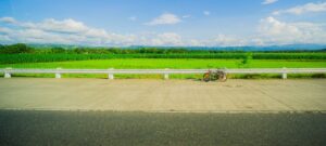
The terrain between Stoughton and Cambridge, Oregon, and McFarland is genuinely good cycling country: rolling glacial landscape, light traffic, good sight lines, and enough small towns at regular intervals to plan a route around lunch or coffee.
A few routes worth knowing:
Stoughton to Cambridge loop: Highway B east from Stoughton toward Dunkirk, north through Deerfield, west on Cambridge Road to Cambridge and back — roughly 40 miles of rolling farmland with minimal traffic and the option to stop in Cambridge’s small downtown.
Stoughton to Oregon: Head west on County Highway B or use surface roads through Rutland — about 11 miles each way, flat to gently rolling, and Oregon has enough going on downtown to justify the turnaround. (Try the Firefly in Oregon for delicious coffees and tasty eats – open weekdays only.)
Lake Kegonsa Circuit: A short, easy loop around Lake Kegonsa State Park and the surrounding roads makes for a 10–15 mile morning ride with lake views, minimal climbing, and the option to add the Lower Yahara trail miles on either end.
Practical Notes for Cycling Southern Wisconsin from our Inn
Bike rentals: Stoton Cycle is great bike shop just a block from the Goose Crown Inn, and rents bicycles by the day.
Maps: We have printed Dane County bike maps on hand at the Goose Crown Inn, for guests. You can also find an interactive version of the Dane County bike map here. The Wisconsin DNR trail pages for each trail include downloadable maps. The Wisconsin Bike Trails website also has detailed section-by-section guides that are geared toward overall trip planning.
Trail passes: Wisconsin State Trail Passes are required for cyclists 16 and older on the Glacial Drumlin, Military Ridge, and the relevant section of the Capital City Trail. $5 daily / $25 annually, purchased at self-pay stations at most trailheads or in advance at the Wisconsin DNR.
Surfaces and bikes: The Glacial Drumlin and Military Ridge limestone sections ride best on a hybrid or gravel bike with tires at least 32mm wide. The Capital City Trail and the Lower Yahara are paved and suit road bikes. If you’re bringing one bike for multiple trails, a hybrid is the most versatile choice.
Season: The trails are officially open spring through fall. Peak season is May through October. The Military Ridge and Glacial Drumlin allow snowmobiles on limestone sections in winter, but are not groomed for cycling.
Hiking instead: Many of the cycling paths and trails in Southern Wisconsin can also be walked. Check out the section on hiking in our general Southern Wisconsin Outdoor Activities writeup.
Need a central place to stay for the bike trails? The Goose Crown Inn is located in the heart of downtown Stoughton — a short ride from the Yahara River corridor and an easy drive to the western trailheads of both the Glacial Drumlin and the Capital City Trail network. Check availability →